


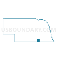
Hardy Precinct, Nuckolls County, Nebraska
About
Outline

Summary
| Unique Area Identifier | 613661 |
| Name | Hardy Precinct |
| County | Nuckolls County |
| State | Nebraska |
| Area (square miles) | 72.22 |
| Land Area (square miles) | 72.12 |
| Water Area (square miles) | 0.10 |
| % of Land Area | 99.86 |
| % of Water Area | 0.14 |
| Latitude of the Internal Point | 40.05262900 |
| Longtitude of the Internal Point | -97.93558880 |
Maps

Graphs
Select a template below for downloading or customizing gragh for Hardy Precinct, Nuckolls County, Nebraska


Neighbors
Neighoring Voting District (by Name) Neighboring Voting District on the Map
- Beaver 1 Precinct, Nuckolls County, NE
- Big Bend Township Voting District, Republic County, KS
- Byron-Chester-Hubbell Precinct, Thayer County, NE
- Deshler Precinct, Thayer County, NE
- Jackson Township Voting District, Jewell County, KS
- Montana Township Voting District, Jewell County, KS
- Nelson Precinct, Nuckolls County, NE
- Spring Creek Precinct, Nuckolls County, NE
Top 10 Neighboring County Subdivision (by Population) Neighboring County Subdivision on the Map
- Superior city, Nuckolls County, NE (1,957)
- Deshler precinct, Thayer County, NE (981)
- Nelson precinct, Nuckolls County, NE (877)
- Chester precinct, Thayer County, NE (696)
- Hardy precinct, Nuckolls County, NE (340)
- Beaver precinct, Nuckolls County, NE (225)
- Spring Creek precinct, Nuckolls County, NE (194)
- Big Bend township, Republic County, KS (177)
- Jackson township, Jewell County, KS (97)
- Montana township, Jewell County, KS (73)
Top 10 Neighboring Place (by Population) Neighboring Place on the Map
Top 10 Neighboring Unified School District (by Population) Neighboring Unified School District on the Map
- Republic County - Hillcrest Rural Schools Unified School District 109, KS (3,825)
- Superior Public Schools, NE (2,985)
- Rock Hills Unified School District 107, KS (2,794)
- Thayer Central Community Schools, NE (2,761)
- Deshler Public Schools, NE (1,402)
Top 10 Neighboring State Legislative District Lower Chamber (by Population) Neighboring State Legislative District Lower Chamber on the Map
Top 10 Neighboring State Legislative District Upper Chamber (by Population) Neighboring State Legislative District Upper Chamber on the Map
- State Senate District 21, KS (61,803)
- State Senate District 32, NE (32,865)
- State Senate District 38, NE (32,734)
Top 10 Neighboring 111th Congressional District (by Population) Neighboring 111th Congressional District on the Map
Top 10 Neighboring Census Tract (by Population) Neighboring Census Tract on the Map
- Census Tract 9631, Thayer County, NE (2,771)
- Census Tract 9600, Nuckolls County, NE (2,394)
- Census Tract 9601, Nuckolls County, NE (2,106)
- Census Tract 9782, Republic County, KS (1,673)
- Census Tract 5761, Jewell County, KS (1,096)
Top 10 Neighboring 5-Digit ZIP Code Tabulation Area (by Population) Neighboring 5-Digit ZIP Code Tabulation Area on the Map
- 68978, NE (2,377)
- 66939, KS (537)
- 68943, NE (269)
- 68325, NE (232)
- 66964, KS (204)
- 68974, NE (184)
- 66970, KS (97)